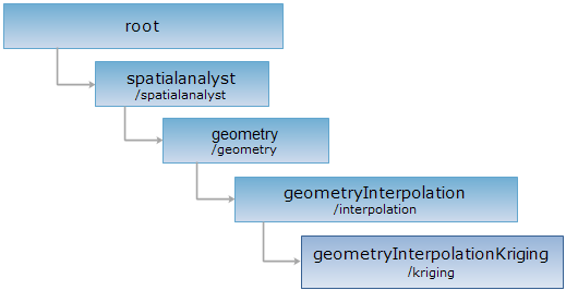
<geometryInterpolation_uri>/kriging[.<format>]
geometryInterpolationKrigingResult
An geometryInterpolationKriging resource can be created by sending a POST request on the resource.
Supported Methods:
Supported output formats: rjson, json, html, xml.

Implement the HTTP request on the following URI, where supermapiserver is the server name, with rjson being the output format.
http://supermapiserver:8090/iserver/services/spatialanalyst-sample/restjsr/spatialanalyst/geometry/interpolation/kriging.rjson
Gets a form for the POST request.
Creates the resource of an interpolation kriging analysis result, i.e., performs an interpolation kriging analysis.
When perform the POST request, the request body should contain the following parameters:
| Name | Type | Description |
| type | InterpolationAlgorithmType | The type of interpolation kriging |
| mean |
double |
[Simple Kriging] The average value of the Z values of the discrete points. |
| angle | double | The angle of rotation. This angle value is the rotation angle of search field to the horizontal direction, the default value is 0. |
| nugget | double | The nugget effect value, the default value is 0. |
| range | double | Self-correlation threshold value, the unit is the sample with the original discrete points, the default value is 0. |
| sill | double | The Sill value, the default value is 0. |
| variogramMode | VariogramMode |
The semi-variable function type in Kriging interpolation. The types include Exponential, Spherical, and Gaussian, the default is Gaussian. The selection of the semi-variable function type will affect the prediction of unknown points, having great significance to different shapes of the curve. The steeper the curve at the original point, the greater impact the neighboring area will have on the prediction, therefore, the less smooth the output surface will be. |
| exponent | Exponent |
[Universal Kriging] The order of the trend surface equation in the sampling data used for interpolation. The optional values are exp1 and exp2, the default is exp1. |
| searchMode | SearchMode | When performing interpolation operation, the mode to search the point used in the operation, fixed point number search, fixed distance query and block query are supported. |
| pixelFormat | PixelFormat | Specify the pixel format of the result raster dataset,it can be: BIT16, BIT32, DOUBLE, SINGLE, UBIT1, UBIT4, UBIT8, UBIT24 or UBIT32. |
| zValueScale | double |
The zoom ratio used in interpolation analysis. The default value is 1. Specifies the zoom scale of the values to be interpolated. |
| resolution | double |
The resolution of the interpolation result raster dataset, that is the actual distance represented by a pixel. The value can't be larger than the bound side length of the discrete point series to analyze. When setting this value, it is needed to consider the size of the point dataset, commonly, the number of rows and column should be no more than 500. |
| searchRadius | double | [Fixed distance query] Search radius, that is the search extent. When calculating the Z value of a location, use the location as the center of a circle, the search extent as the radius, the points that falls in the extent will be used in the calculating. This value can be set based on the distribution of the point data and bounds of the discrete point series. |
| expectedCount | int |
[Fixed point number query] Set the number of points to query, the default is 12. |
| maxPointCountForInterpolation | int |
[Block query] The sum total of the points in the interpolation in block search, the default is 200. |
| maxPointCountInNode | int |
[Block query] The maximum point number in a single block to used in the operation, the default is 50. |
| outputDatasetName | String | The name of the interpolation analysis result dataset. |
| outputDatasourceName | String | The name of the interpolation analysis result datasource. |
| inputPoints | Point3D[] | The coordinates (including Z values) of the discrete points to perform interpolation analysis. |
| bounds | Rectangle2D | The bounds for interpolation analysis, which will be used to determine the bounds of the result grid dataset. The default is the bounds of the discrete point series. |
| clipParam | ClipParameter | The parameters used to clip the interpolation result. |
Normal response code(s): 201. The response parameters are as follows:
| Field | Type | Description |
| succeed | boolean | Whether the query is successful. |
| newResourceID | String | The ID for the analysis result resource. |
| postResultType | PostResultType | The result type fo the POST request. |
| newResourceLocation | String | The URI of the newly created resource. |
Suppose we implement the POST request on the geometryInterpolationKriging resource, or submit the following request body for http://localhost:8090/iserver/services/spatialanalyst-sample/restjsr/spatialanalyst/geometry/interpolation/kriging.rjson:
{
"type":"KRIGING",
"angle":0,
"nugget":0,
"range":0,
"sill":0,
"variogramMode":"SPHERICAL",
"searchMode":"KDTREE_FIXED_RADIUS",
"searchRadius":0,
"expectedCount":12,
"pixelFormat":"BIT16",
"zValueScale":1,
"resolution":3000,
"outputDatasetName":"kriging",
"outputDatasourceName":"Interpolation",
"inputPoints":[{"z":-3, "y":5846399.011754164, "x":1210581.346513096}, {"z":-2, "y":5806144.683668519, "x":1374568.1968855715}, {"z":0, "y":5770737.831291649, "x":1521370.8530005363}, {"z":-1, "y":5528199.929583105, "x":1095631.459772168}, {"z":-3, "y":5570741.490646067, "x":1198626.2178598372}, {"z":0, "y":5593290.502553593, "x":1373169.3807736137}, {"z":1, "y":5627352.642284978, "x":1612502.8281910105}, {"z":0, "y":5411257.388322545, "x":1081393.2452306528}, {"z":1, "y":5458415.294482666, "x":1369469.8846276255}, {"z":1, "y":5476577.894029853, "x":1479703.1555390327}, {"z":1, "y":5538359.532668987, "x":1625450.5930904327}, {"z":2, "y":5322253.555958582, "x":874680.7560980343}, {"z":0, "y":5387691.351356046, "x":1247212.6046764243}]
}
The response information in rjson format returned is as follows:
{
"succeed":true,
"newResourceID":"fvmhhtsg_ae18346abd1f449b9a8947252c5f10e2",
"postResultType":"CreateChild",
"newResourceLocation":"http://localhost:8090/iserver/services/spatialanalyst-sample/restjsr/spatialanalyst/geometry/interpolation/kriging/fvmhhtsg_ae18346abd1f449b9a8947252c5f10e2"
}
Performing a GET request on http://localhost:8090/iserver/services/spatialanalyst-sample/restjsr/spatialanalyst/geometry/interpolation/kriging/fvmhhtsg_ae18346abd1f449b9a8947252c5f10e2.rjson can retrieve detailed information about the Kriging interpolation analysis result. Please see geometryInterpolationKrigingResult.
Asks for the response identical to the one that would correspond to a GET request, but without the response body. This is useful for retrieving meta-information written in response headers, without having to transport the entire content. The meta-information includes the media-type, content-encoding, transfer-encoding, content-length, etc.
HEAD request can be used to check if the geometryInterpolationKriging resource exists, or if the geometryInterpolationKriging resource can be accessed by clients. It can also determine if the geometryInterpolationKriging resource supports an output format <format> if performed on a URI with .<format> included.