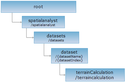
<dataset_uri>/terraincalculation[.<format>]
The root resource for terrain analysis. It is the entry to all terrain resources.
Terrain calculation refers to making terrain calculation on grid data. The main source data are DEM. Digital Elevation Model (DEM) is composed of a set of ordered terrain elevations. DEM also virtually describes the terrain shapes and make terrain analysis. So, it is widely used in the sectors of hydrology, geomorphology, geology, meteorology, military, etc.
Supported Methods:
Supported output formats: rjson, json, html, xml.

Implement the HTTP request on the following URI, where supermapiserver is the server name, with rjson being the output format.
http://supermapiserver:8090/iserver/services/spatialanalyst-sample/restjsr/spatialanalyst/datasets/JingjinHillshade@Jingjin/terraincalculation.rjson
Get the child resources of terrain calculation.
Return all the child resources of terrain calculation methods.
| Field | Type | Description |
| name | string | The name of the child resource. |
| path | string | The URI of the child resource. |
| resourceConfigID | string | The ID of the resource configuration file. |
| resourceType | ResourceType | The resource type. |
Performing a GET request on http://localhost:8090/iserver/services/spatialanalyst-sample/restjsr/spatialanalyst/datasets/JingjinHillshade@Jingjin/terraincalculation.rjson can retrieve detailed information on the terrainCalculation.
[{
"name": "curvature",
"path": "http://localhost:8090/iserver/services/spatialanalyst-sample/restjsr/spatialanalyst/datasets/JingjinHillshade@Jingjin/terraincalculation/curvature",
"resourceConfigID": null,
"resourceType": null,
"supportedMediaTypes": null
}]
Asks for the response identical to the one that would correspond to a GET request, but without the response body. This is useful for retrieving meta-information written in response headers, without having to transport the entire content. The meta-information includes the media-type, content-encoding, transfer-encoding, content-length, etc.
HEAD request can be used to check if the terrainCalculation resource exists, or if the terrainCalculation resource can be accessed by clients. It can also determine if the terrainCalculation resource supports an output format <format> if performed on a URI with .<format> included.