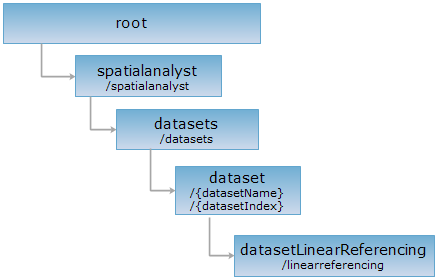
<dataset_uri>/linearreferencing[.<format>]
Linear reference resource, it's the gate of dynamic segmentation. Dynamic segmentation is not the physical segmentation at the location where certain attribute of the line feature changed. It uses linear referencing technology on traditional GIS data models, and stores the attributes and their corresponding linear feature location in an independent event attribute table (event table). It segments the linear features with dynamic logic segmentation method based on the distance stored in the event attribute table and automatically calculate the spatial positions of the attribute data in the analysis, display, query and output operations.
The general process of dynamic segmentation:
Only creating spatial data with point/line event table is supported currently.

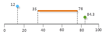
The following is a diagram of linear reference, the line at the bottom is a line segment with measure value (such as road, pipeline, etc), the points and line segments on the line are the events on the line. They are describes as the point whose distance from the start location is 12 unit, the line start at 35 unit and end at 76, the point at the 84.3 unit.
Basic Concepts:
In SuperMap, there are two types of data structure for dynamic segmentation: route and event.
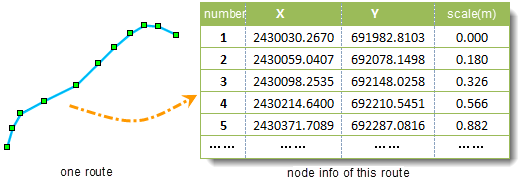
Route: Route is a linear feature (such as the road, street, river, pipe, etc.) that is characterized of ID and measure system, and it has a position ID and a measure value (generally used M to describe it like mileage).
Measure Value (M): Measure Value is a coordinate system that is independent of the other feature classes. The unit between the Measure value and other features isn't necessary to be the same.

Route position: describes a "point" in the route or a "section" along the route. A point in the route position is described by a Measure value, and a line in the route position is described by two Measure values: Start Measure and End Measure.
Event: When the route positions and their associated attributes store in one table, a route event will be organized, which is called event for short. There are two kinds of route positions, so they are corresponding to two types of route event table: point event table and line event table. An event table contains at least two fields: Route ID field and route position field. Route ID field is a number or character that marks the route event. Route position field describes one or two accident positions field along the route. See EventType.
Zero-length event: The starting measure is equal to the end measure. If it is allowed to set a tolerance, then the absolute value of the start measure minus the end measure is less than the tolerance, it can also be seen as a zero-length event.
Route ID field: A field in the rout dataset, storing the route ID. The Route dataset, the event table and the spatial data contain this field. Note that the field can only be numeric.
Supported Methods:
Supported output formats: rjson, json, html, xml.

Implement the HTTP request on the following URI, where supermapiserver is the server name, with rjson being the output format.
http://supermapiserver:8090/iserver/services/spatialanalyst-changchun/restjsr/spatialanalyst/datasets/RouteDT_road@Changchun/linearreferencing.rjson
Get the linear reference analysis resource supported by the current dataset.
Return the linear analysis resource supported by the current dataset, including resource name, path, type, etc.
| Field | Type | Description |
| name | string | The name of the child resource. |
| path | string | the URI of the child resource. |
| resourceConfigID | string | The ID of the resource configuration file. |
| resourceType | ResourceType | The resource type. |
| supportedMediaTypes | string[] | The supported media types. |
| visible | Boolean | Whether visible, the default is true. |
Perform GET request on http://localhost:8090/iserver/services/spatialanalyst-changchun/restjsr/restjsr/spatialanalyst/datasets/RouteDT_road@Changchun/linearreferencing.rjson, the rjson format representation returned is as the following:
[{
"name": "generateSpatialData",
"path": "http://localhost:8090/iserver/services/spatialanalyst-changchun/restjsr/spatialanalyst/datasets/RouteDT_road@Changchun/linearreferencing/generatespatialdata",
"resourceConfigID": null,
"resourceType": null,
"supportedMediaTypes": null,
"visible": true
}]
Asks for the response identical to the one that would correspond to a GET request, but without the response body. This is useful for retrieving meta-information written in response headers, without having to transport the entire content. The meta-information includes the media-type, content-encoding, transfer-encoding, content-length, etc.
HEAD request can be used to check if the linearReferencing resource exists, or if the resource can be accessed by clients. It can also determine if the linearReferencing resource supports an output format <format> if performed on a URI with .<format> included.