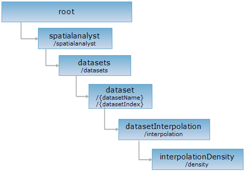
<datasetInterpolation_uri>/density[.<format>]
Get the raster dataset that reflect data distribution density by perform interpolation analysis on point dataset. The difference between interpolation analysis: the interpolation fields are the weight of the points, the result reflect the distribution density of the data points.
You can create a point density interpolation analysis result resource by sending POST request to the resource.
Supported Methods:
Supported output formats: rjson, json, html, xml.

http://supermapiserver:8090/iserver/services/spatialanalyst-sample/restjsr/spatialanalyst/datasets/SamplesP@Interpolation/interpolation/density.rjson
Gets a form for the POST request.
Creates the resource of an density interpolatio analysis result, i.e., performs an density interpolatio analysis.
When perform the POST request, the request body should contain the following parameters:
| Name | Type | Description |
| searchRadius | double | Search radius, that is the search extent, the unit is the same with the dataset unit. When calculating the Z value of a location, use the location as the center of a circle, the search extent as the radius, the points that falls in the extent will be used in the calculating. This value can be set based on the distribution of the point data and point dataset extent. |
| pixelFormat | PixelFormat | Specify the pixel format of the result raster dataset,it can be: BIT8, BIT16, BIT32, DOUBLE, SINGLE, UBIT1, UBIT4, UBIT8, UBIT16, or UBIT32. |
| zValueFieldName | String | Stores the field name used for interpolation analysis, text fields are not supported. It means the weight of every interpolation point, you can set this value of all the points as 1, that is all the points have the same weight. |
| zValueScale | double | The scale used in the interpolation analysis, the default is 1. The values used in the interpolation analysis is multiplied by this value. |
| resolution | double | The resolution of the interpolation result raster dataset, that is the actual distance represented by a pixel, the unit is the same with the point dataset. The value can't be larger than the side of the dataset extent to analysis. When setting this value, it is needed to consider the size of the point dataset, commonly, the number of rows and column should be no more than 500. |
| bounds | Rectangle2D | The extent of the interpolation analysis, used to determine the extent of the result raster dataset. It's the extent of the original dataset by default. Since it is the method of interpolation, only the result inside the original dataset is meaningful, so it is recommended that this parameter should not larger than the original dataset extent. |
| filterQueryParameter | QueryParameter | |
| outputDatasetName | String | The name of the interpolation analysis result dataset. |
| outputDatasourceName | String | The name of the interpolation analysis result datasource. |
| clipParam | ClipParameter | The parameter used to clip the interpolation results. |
Normal response code(s): 201. The response parameters are as follows:
|
Field |
Type | Description |
| succeed | Boolean | Whether the query is successful. |
| newResourceID | String | The ID for the analysis result resource. |
| postResultType | PostResultType | |
| newResourceLocation | String | The URI of the newly created resource. |
Perform POST request on interpolationDensity resource, that is submit request body to http://localhost:8090/iserver/services/spatialanalyst-sample/restjsr/spatialanalyst/datasets/SamplesP@Interpolation/interpolation/density.rjson, as shown below:
{
"searchRadius": "100000",
"pixelFormat": "BIT16",
"zValueFieldName": "AVG_TMP",
"resolution": 3000,
"filterQueryParameter": {
"attributeFilter": ""
},
"outputDatasetName": "test_Density",
"outputDatasourceName":"Interpolation"
}
The response information in rjson format returned is as follows:
{
"succeed": true,
"newResourceID": "mi92arb7_98450daa266f490ab20c9fb68a08b893",
"postResultType": "CreateChild",
"newResourceLocation": "http://localhost:8090/iserver/services/spatialanalyst-sample/restjsr/spatialanalyst/datasets/SamplesP@Interpolation/interpolation/density/mi92arb7_98450daa266f490ab20c9fb68a08b893"
}
Performing a GET request on http://localhost:8090/iserver/services/spatialanalyst-sample/restjsr/spatialanalyst/datasets/SamplesP@Interpolation/interpolation/density/mi92arb7_98450daa266f490ab20c9fb68a08b893.rjson can retrieve detailed information about the interpolation analysis result. Please see interpolationResult.
Asks for the response identical to the one that would correspond to a GET request, but without the response body. This is useful for retrieving meta-information written in response headers, without having to transport the entire content. The meta-information includes the media-type, content-encoding, transfer-encoding, content-length, etc.
HEAD request can be used to check if the interpolationDensity resource exists, or if the resource can be accessed by clients. It can also determine if the interpolationDensity resource supports an output format <format> if performed on a URI with .<format> included.