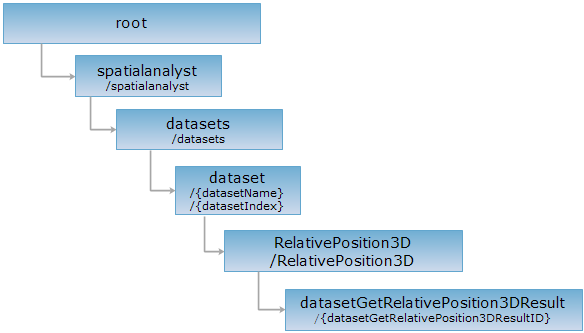
<RelativePosition3D_uri>/{datasetGetRelativePosition3DResultID}[.<format>]
The 3D spatial analysis result resource, used to get the specified spatial relation.
Supported methods:
Supported output formats: RJSON, JSON, HTML, XML.

Execute HTTP request on the following URI, here we take rjosn as the output format as an example. Where, supermapiserver is the server name.
http://supermapiserver:8090/iserver/services/spatialAnalysis-BIM2/restjsr/spatialanalyst/datasets/结构柱@8ExportModel/RelativePosition3D/{datasetGetRelativePosition3DResultID}.rjson
Returns the result of 3D spatial analysis.
Perform a GET request on the current resource, the response fields are as follows:
| Field | Type | Description |
| succeed | boolean | Marks whether the analysis is successful. |
| ids | int[] | The IDs of analysis result. |
| posMode | PositionMode | Spatial relation types, including: UNKNOWN, IDENTICAL, DISJOINT, INTERSECTS, WITHIN, CONTAINS, INTERSECTSORCONTAINS. |
| message | String | The information generated duiring 3D spatial analysis process. |
Perform a GET request on the current resource, the returned result in json format is as follows:
{
"succeed":true,
"ids":null,"
posMode":"DISJOINT",
"message":"DISJOINT"
}
Returns the same HTTP response header as the GET request, but no response entity, which can be used to retrieve the meta data contained in response message header without having to transmit the entire response content. Meta data information includes media type, character coding, compression coding, entity content length, etc.
HEAD request is used to determine whether the datasetGetRelativePosition3DResult resource exists, or if the user has the authority to access it. By executing an HEAD request with a .<format> URI, you can quickly determine whether the datasetGetRelativePosition3DResult resource supports the <format> representation.