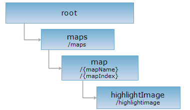

<map_uri>/highlightimage[.<format>]
ERROR: Variable (map_link) is undefined.
The highlightImage resource can be used to highlight a specific target set or a query result. It returns an image either with the highlighted objects alone, or with the highlighted objects overlaying on a certain base map. Specifically, the highlighted image is retrieved by GET, which provides the SuperMap iServer with information about the target set, the query result, and other layers to be overlaid, through including corresponding parameters in the URI for the GET request. If a query result is to be highlighted in an image, the highlighting style can also be specified by passing the style parameter style.
Supported Methods:
Supported output formats: PNG, RJSON, JSON, HTML, XML.

Implement an HTTP request on the following URI and return the response in rjsonformat. In the URI, supermapiserver is the name of the server, and WorldMap is the map name (mapName). The URI represents the highlightImage resource, which can be used to retrieve the highlighted image given proper parameters.
http://supermapiserver:8090/iserver/services/map-world/rest/maps/WorldMap/highlightimage.rjson
Gets a specific highlighted image. Parameters such as the target set or the query result to be highlighted are all included in a URI.
The request parameters of the highlightImage resource must be included in the URI. The following is a list of all the parameters. Each request can have either a highlightTargetsID or a queryResultID, indicating that the output image is either highlighting a specific target set, or a query result.
| Name | Type | Description |
| redirect | boolean | Whether to redirect. If true, the request would be redirected to the real address of the image; if false, the byte stream of the image would be in the response body. The default is true. |
| highlightTargetSetID | String | [Required parameter] Not compatible with queryResultID. The target set resource to be highlighted in the output image, i.e., the ID of the highlightTargetSet resource. |
| queryResultID | String | [Required parameter] Not compatible with highlightTargetSetID. The query result resource to be highlighted in the output image, i.e., the ID of the queryResult resource. |
| style | Style | The style of highlighting query results. |
| center | Point2D | Specifies the center point of the map display. |
| scale | double | Specify the scale of the map. See definition of scale. |
| width | int | Specifies the width of the display window/the output image. Must be used together with height. Priority is higher than viewer. |
| height | int | Specifies the height of the display window/the output image. Must be used together with width. Priority is higher than viewer. |
| viewer | Rectangle | Specifies the size of the display window/the output image. The default size is 256*256 pixels. |
|
viewBounds |
Rectangle2D | Specifies the geographic extent of the map view. |
| layersID | String | The ID of the temporary layers to be mapped in the output image. The temeporary layers are created by temLayersSet resource. |
| dynamicProjection | boolean | Whether to allow dynamic projection while displaying the map. |
| prjCoordSys | PrjCoordSys | The coordinate system requested. The system will perform dynamic projection if the coordinate system be set is different from the original coordinate system, the map image will be returned at the same time. Parameter usage example: |
| _cache | boolean |
Whether to use cache, the default is True. False means close all the caches. |
| customParams | String |
Custom parameters They can be strings with any combination of characters. This is for users to pass any custom parameters. |
| rectifyType | RectifyType | The rectification method . |
| clipRegion | Geometry | The clipped region on the map for display. This is an areal object, and is supported only when clipRegionEnabled = true, indicating that only the part of the map covered by clipRegion will be displayed. |
| clipRegionEnabled | boolean | Whether clipRegion is enabled. |
| customEntireBounds | Rectangle2D | Custom map boundary. Valid when customEntireBoundsEnabled is true. |
| customEntireBoundsEnabled | boolean | Whether customEntireBounds is enabled. |
| angle | double | The rotation angle of the map. |
| antialias | boolean | Whether the map is anti-alias. |
| backgroundStyle | Style | The background style of the map. |
| colorMode | MapColorMode | The color mode of the map. |
| markerAngleFixed | boolean | Whether the angle of marker symbols is fixed. |
| maxVisibleTextSize | double | The maximum visible size (in pixels) of the text. |
| maxVisibleVertex | int |
The maximum visible vertices of the geometric object. If a geometric feature has more than maxVisibleVertex vertices, the extra vertices will not be displayed. |
| minVisibleTextSize | double | The minimum visible size (in pixels) of the text. |
| overlapDisplayed | boolean | Whether to display the objects when the map object is in the same extent. The default is False. If it is true, the objects in the same extent will be directly overlapped; If it is False, it doesn't display through overlapDisplayedOptions. |
| overlapDisplayedOptions | OverlapDisplayedOptions | Avoid the map object overlapping the filter options. When the overlapDisplayed is false, it is used to enhance the processing when map objects overlap. |
| paintBackground | boolean | Whether to render the background of the map. |
| textAngleFixed | boolean | Whether the angles of the text are fixed. |
| textOrientationFixed | boolean | Whether the orientations of the text are fixed. |
If the highlighted image is directly retrieved, the output format can be set to PNG. An image will then be returned.
If information about the highlighted image is retrieved, the output format can be set as RJSON, JSON, HTML, or XML. The returned representation structure will be as follows:
| Field | Type | Description |
| customResponse | String | The custom response. |
| imageData | byte[] | The binary stream of the map image. |
| lastModified | long | The last modified time of the map. |
| imageUrl | String | A URI directed to the map image in PNG format. |
| mapParam | MapParameter | Map parameters. |
As an example, output a highlight target set (See highlightTargetSetresource), the ID is 損cg70k3e_17cacff656b74cca9fce82354cf4b82e? the output result of the PNG format can be got through the two URIs below, the former is the result of the original coordinate system, and the latter is the result after projected to {"epsgCode":3857}.
http://supermapiserver:8090/iserver/services/map-world/rest/maps/WorldMap/highlightimage.png?highlightTargetSetID=pcg70k3e_17cacff656b74cca9fce82354cf4b82e¢er={"x":110.0,"y":35.0}&scale=0.00000003
http://supermapiserver:8090/iserver/services/map-world/rest/maps/WorldMap/highlightImage.png?highlightTargetSetID=pcg70k3e_17cacff656b74cca9fce82354cf4b82e¢er=center={"x":12245143.99,"y":4160330.24}&scale=0.00000003&prjCoordSys={"epsgCode":3857}
| Output result 1 | Output result 2 |
|
|
|
Asks for the response identical to the one that would correspond to a GET request, but without the response body. This is useful for retrieving meta-information written in response headers, without having to transport the entire content. The meta-information includes the media-type, content-encoding, transfer-encoding, content-length, etc.
The HEAD request helps check the existence of the highlightImage resource and whether it can be accessed by the client. By implementing the HEAD request on the URI, with .<format> appended to the end, we can quickly get to know whether the highlightImage resource supports the representation in <format> or not.