Configuring service interfaces through iServer Manager |
SuperMap iServer not only supports standard WMS (Web Map Service) interface, WFS (Web Feature Service) interface, WMTS (Web Map Tile Service) interface, WCS (Web Coverage Service) and REST/JSR service interface, but also allows users to customize the interface types. Currently, SuperMap iServer supports WMS 1.1.1 and 1.3.0, WFS 1.0.0 and 2.0.0, WMTS 1.0.0, WCS 1.1.1 and 1.1.2.
After logging in to iServer Manager, on Services>Interfaces page, users can add a new service interface, modify an existing service interface, or delete a service interface. The * on the page represents the parameter is required.
The detailed operations about service interface are shown below:
When you add a custom interface type, resource alias, resource type and configuration class parameters are required. Resource alias indicates the alias of the resource class. Resource type indicates the name of the implementation class of the custom interface type. Configuration class indicates the configuration class of the custom interface type.
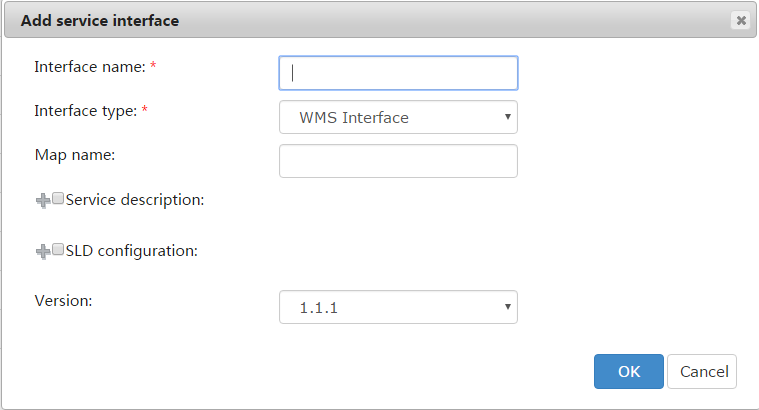
You need to specify interface name, interface type, etc.
Except for specifying interface name, interface type, you still need to specify map name, service description, version, etc. Among those parameters, interface name and interface type are required. The map name in the WMS service can be any map name in the workspace. The default map name is the name of the first map in workspace. Therefore, you should clearly know the map names and its orders in the workspace; the service description illustrates the service information. This information includes the service name, title, server description, key word, online resource, cost, access constraints, etc; SLD (Styled-Layer Descriptor) configuration information is used to configure layer style for the WMS service. Please refer to Using SLD for more information. iServer supports SLD in WMS 1.1.1, which can configure point, line, region and text layers; Version: Now, SuperMap iServer 11i(2024) supports both WMS 1.1.1 and WMS 1.3.0. Users can select the version as they like.
The following is an example about adding a WMS service interface. When the you set the parameters and click OK, the added interface will be displayed on the Interfaces page.
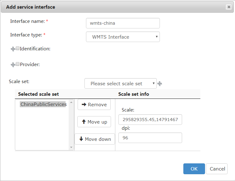
Except for interface name, interface type, you still need to specify parameters such as service identification information, provider information, well-known scale set (scale, DPI). Among all these parameters, interface name and interface type are required. Service identification information includes title, description, keywords, fees, access constraints, service type, and service type version. Service provider information includes provider name, provider website, contact information, etc. The Well-known scale set parameter is the scale set in WMTS. There are six optional values: GlobalCRS84Scale, GlobalCRS84Pixel, GoogleMapsCompatible, GoogleCRS84Quad ChinaPublicServices and Custom. Please refer to WellknownScale. SuperMap iServer supports users in setting custom scale set in WMTS interface.
The scales on which SuperMap iServer WMTS service is based is calculated with: Scale = 1 : Ground Resolution (a) * Screen Resolution (dpi)/0.0254(m/feet). Where, Ground Resolution (a) refers to the distance a pixel represents, with the unit of m. Screen Resolution (dpi) refers to pixels an inch contains on the screen. For example, 96dpi represents that there are 96 pixels in each inch. 0.0254(m/in) is the conversion ratio between meter and inch. The scale set in WMTS specification is calculated based on the cell size of 0.28mm, therefore, we can get the number of pixels per inch, that is, the dpi value. From the formula, we can see that the scale is different for the same data with the same resolution but the dpi is different. Since dpi is so important, it should be specified while creating a new WMTS interface.
While creating a new WMTS interface, if the scale is set to Custom but dpi is not set, the dpi specified in WMTS 1.0.0 specification will be used, that is, the dpi value while the cell size is 0.28mm will be used. If the custom scale is set, the parameter refers to the denominator of the scale.
To follow the related laws about map classification in "Platform for geoinformation common services -- Data specification for electronic map" published by National Administration of Surveying, Mapping and Geoinformation of China, SuperMap iServer provides the "wmts-China" instance extended based on the WMTS interface to provide tile map service based on the tiling levels often used in China. Where, wellKnownScaleSet needs to be set to ChinaPublicServices. The scale set is as follows, with the dpi being 96.
| Level | Ground resolution (m/px) | Display scale |
| 1 |
78,271.5170 |
1:295,829,355.45 |
| 2 | 39,135.7585 | 1:147,914,677.73 |
| 3 | 19,567.8792 | 1:73,957,338.86 |
| 4 | 9,783.9396 | 1:36,978,669.43 |
| 5 | 4,891.9698 | 1:18,489,334.72 |
| 6 | 2,445.9849 | 1:9,244,667.36 |
| 7 | 1,222.9925 | 1:4,622,333.68 |
| 8 | 611.4962 | 1:2,311,166.84 |
| 9 | 305.7481 | 1:1,155,583.42 |
| 10 | 152.8741 | 1:577,791.71 |
| 11 | 76.4370 | 1:288,895.85 |
| 12 | 38.2185 | 1:144,447.93 |
| 13 | 19.1093 | 1:72,223.96 |
| 14 | 9.5546 | 1:36,111.98 |
| 15 | 4.7773 | 1:18,055.99 |
| 16 | 2.3887 | 1:9,028.00 |
| 17 | 1.1943 | 1:4,514.00 |
| 18 | 0.5972 | 1:2,257.00 |
| 19 | 0.2986 | 1:1,128.50 |
| 20 | 0.1493 | 1:564.25 |
The above WMTS related parameters settings are show below.
The configuration of the service interface includes the following two aspects: the basic configuration and the interface object configuration.
For a WMS service interface, the interface name, map name, service description, and version can be modified. Note: Users can reset the name of the map to be published by modifying the map name.
For a WMTS service interface, the interface name, well-known scale set, identification information, service provider information, etc., can be modified. For details, see: Adding a WMTS Service Interface.
For a REST service interface, or a REST/JSR service interface, or a ArcGIS REST service interface, or a Baidu REST service interface, or a Google REST interface, or a WPS service interface, only the interface name can be edited.
For a WFS service interface, the interface name and the version information support to be edited.
For a WCS service interface, you can modify the interface name, version information and service identification.
You can delete one or more service interfaces in the interfaces list:
1. Select one or more service interfaces to be deleted
2. Click the Delete button
3. Click Yes in the dialog box
Note 1: If you want to use these interfaces in iServer: ArcGIS REST, Baidu REST, Google REST, first you need to purchase iServer Advanced Edition; In iEdge, you can use them directly.