Introduction to SuperMap GIS 2025 Product System |
SuperMap GIS is a new generation of cloud-integrated GIS platform software based on the new architecture of SuperMap Software. Based on the three technical systems of cross-platform, 2D and 3D integration and cloud integration, it provides powerful functions. GIS portal software platform, server GIS software platform and GIS edge software platform, as well as rich PC, Web and mobile products and development packages, help customers to build strong cloud rich, interconnected, stable, flexible and reliable GIS system.
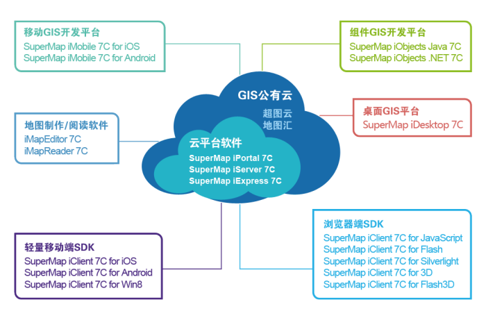
Based on the GIS public cloud service provided by SuperMap GIS and cloud GIS platform software such as iPortal, iServer and iEdge, you can easily build powerful and cross-platform cloud GIS service applications; based on SuperMap GIS provides iObjects, iDesktop, iMobile, iClient, iMapReader and other types of GIS products. You can build a variety of cross-platform clients to connect the cloud GIS service platform, supermap cloud service, etc. At the same time, 2D and 3D integration technology runs through all products to help you build more gorgeous and practical 3D applications.
SuperMap GIS public cloud service, including SuperMap cloud (http://www.supermapcloud.com/) and Dituhui (http://dituhui.com/).
SuperMap cloud provides geographic data services (Geo-DaaS), GIS platform services (Geo-PaaS), industry application services (Geo-SaaS), GIS data provision, GIS online services, industry solution hosting, etc., and provides GIS online store (Geo Store (http://istore.supermap.com.cn/) for online sharing and trading of application plug-ins, GIS symbols, and maps.
Dituhui is an interactive Internet map application product deployed in SuperMap Cloud, which provides an online geographic information service to enterprise users, individual users and developers through B2B, B2C and B2D business models; It is easy to map the table data, realize the online production of thematic maps, and provide the basis for management decision-making by overlapping analysis, buffer analysis and data mining of authoritative data for enterprise users.
Building a GIS cloud or GIS server system requires the troika of SuperMap GIS, which are:
SuperMap iPortal: GIS portal software platform, which can provide the ability to integrate, manage, collaboratively create and share various GIS resources, and provide a customizable GIS portal software platform to support the GIS cloud system.
SuperMap iServer: Server GIS software platform is an enterprise-level large-scale GIS service development platform based on cross-platform GIS kernel and cloud computing technology. It is used to build SOA application system and GIS private cloud system by adopting service-oriented geographic information sharing mode.
SuperMap iEdge: GIS edge software platform, which is a GIS edge server platform, deployed near the client or data source side for nearby real-time analysis and processing, which can reduce response delay and bandwidth consumption, and reduce the pressure on the cloud GIS center. It can be used as a proxy and accelerator between GIS services and end users, so that users can really enjoy smooth remote cloud services through localized map caching strategy (grid + attribute + vector).
The troika of SuperMap GIS uses parallel computing, intelligent cluster, cross-platform and 64-bit computing technologies to help users save resources and realize the core value of cloud computing through intensive computing and services.
The terminal GIS platform software of SuperMap GIS includes the following categories, covering various products on PC, Web and mobile terminals, which can be connected to the cloud GIS platform and SuperMap public cloud platform for map production, business customization, terminal display, data update and other processes.
Component GIS development platform: SuperMap iObjects Java, SuperMap iObjects .NET。 The full-function GIS application secondary development platform is used to build GIS stand-alone system and C/S system, and provides Java and.NET APIs.
Desktop GIS Platform: SuperMap iDesktopX. Professional GIS data analysis, processing, mapping platform, and support.NET environment under the expansion of development, rapid customization of industry applications.
Map making/reading software: iMapEditor, iMapReader. Lightweight map editing and reading tools are interconnected with the SuperMap Store.
Mobile GIS development platform: SuperMap iMobile for iOS/Android. Full-function mobile GIS development platform, supporting 2D and 3D integrated display, path navigation, etc., and supporting iOS and Android platforms.
Lightweight Mobile SDK: SuperMap iClient for iOS/Android/Win8. Lightweight, fast and free GIS mobile development kit, supports online connection to SuperMap cloud GIS platform and supermap cloud service, supports offline tile caching, and supports iOS, Android and Windows Phone 8 platform.
Browser-side SDK: SuperMap iClient for JavaScript/Flash/Silverlight, SuperMap iClient for 3D/Flash3D。 It covers JavaScript, Flash, Silverlight and other common Web development platforms, and provides two-dimensional and three-dimensional integration capabilities on the Web side.